Day 11: Trekking Tongariro Alpine Crossing in New Zealand
The Trekking Tongariro Alpine Crossing in New ZealandIt was one of the main reasons for this trip to New Zealand in 36 days and finally the day has come when we will know this incredible place, considered by many as the most beautiful day trekking in the world.
The alarm sounds when it is 4:30 in the morning, at which time it is time to pick up everything in the Jucy motorhome, put on our trekking boots, have a coffee and have breakfast, for when there are a few minutes until 6 to make way to Ketetahi, The end point of the Tongariro trekking, where the meeting point is located, from where the shuttel we booked yesterday, takes us in 30 minutes to Mangatepopo, the gateway to the trekking.
Remember that if you are interested in making a route through New Zealand by motorhome, we recommend you look at the Motorhome Republic page where you can see all the available motorhome options, prices and make the reservation directly.
From this point and knowing all the doubts we had when deciding whether or not to make the Tongariro trekking, we want to tell all the details of this walk, as well as how the experience of enjoying a day of the New Zealand's most famous trekking.
Tongariro Alpine Crossing in New Zealand
The first thing we think is important, is to know a little where the Tongariro Alping Crossing or Trekking Tongariro in New Zealand. This location, famous for the filming of many films, among which The Lord of the rings, which made it even more known, is located in the Tongariro National Park, and occupies an area of land of almost 800km2 of the North Island of New Zealand.
Its most famous area, which is where the trekking runs, are three active volcanoes: the Ruapehu, the Ngauruhoe and the Tongariro. All of them can be seen on clear days from different points of the walk, as well as lakes of impossible colored waters and landscapes that seem like another world.

Tongariro Alpine Crossing Trekking
Mount Ruapehu is the highest of all with 2797 meters and is also considered one of the most active volcanoes in the world, especially after the eruption of 1953 when one of the edges collapsed, dragging everything in its path, including a bridge through which a train passed, causing the death of 150 people.
Currently this volcano is still active, as are its neighbors, so even if it looks like a joke They already warn you that in case of alarm, do not stop and continue the road as quickly as possible, without looking back.
The Tongariro, with 1967 meters is the lowest mount, but also one of the most famous of which also receives the name of the park. Currently still active and the last major eruption was in 2012 and caused the trekking to be suspended for a year.

Sunrise in the Tongariro
And finally, in the northeast area of the Ruapehu it can be seen on Mount Ngauruhoe of 2287 meters, also known as the Mount of Destiny in the film The Lord of the rings. With a perfect conical shape, this is one of the most impressive views of the Tongariro trekking, whether or not you are a fan of the trilogy and of course, one of the must-see places in New Zealand.

Mount ngauruhoe
Tongariro Trekking Facts
We leave you the most basic data of the Tongariro trekking, so that from the beginning, you can know the most basic aspects and determine if it fits in your trip.
- Duration: 6-8 hours. We did it in 9 but in the area of the Red Crater and Emerald Lakes we stopped practically an hour to take photos and we also made a 30-minute stop at La Laguna Azul to eat.
- Distance to travel: 19.4 kilometers. Remember that it is not circular.
- Difficulty: Although everyone (or most), considers this trekking difficult, we after the experience more than difficult, we would say that it is exhausting in the last part, since they are several hours of continuous descent, in which the knees and The legs seem to be unable to give more. Yes, there is some tired stage or that of the Red Crater, in which the descent is complicated by being very slippery.

Tongariro Trekking Map. Image of the official website of Tongariro Park
How to get to the beginning of Tongariro Alpine Crossing?
After this little introduction, we want to explain how to get to Tongariro Alpine Crossing Y where the Tongariro trekking begins and ends, since we know from experience that it is not easy to understand if you have not read about this topic.
The first thing to know is that this trekking is not circular, so you will need a transport that will take you from the end point to the starting point, where you will have left your vehicle.
Map of Tongariro Alpine Crossing locations
As you can see in the following image, the trekking is not circular, so as we commented, whenever you want to have your vehicle, you should:
1. Search for accommodation (Point D) in the beginning or end zone of the trekking. This is not essential, but according to our experience it is highly recommended considering that the best thing is to start early in the morning and when you finish, all you will need is a shower and rest. We stayed at the Tongariro Holiday Park, which is one of the most recommended accommodation in Tongariro.
2. Go in your vehicle from your accommodation to Point C (Ketetahi), which is the end of the trekking, by the time you finish, have the motorhome.
3. Book a shuttle to take you from Point C (Ketetahi) to Point A (Mangapopo), to start the Tongariro Alpine Crossing.
4. Keep in mind that there are several companies to carry out this transfer and it is advisable to book them in advance. We opted for Mountain Shuttle, since it offered us secure parking and knowing that in recent times there have been some cases of theft, we prefer to opt for them.
All of them have several departures, usually between 6 and 10 in the morning, which allow you to perform the trekking perfectly.
Another option is to book this round trip transfer at the Tongariro Alpine crossing.
5. As you can see in the photo, once you finish the trekking, you will arrive at Point C (Ketehahi), where you will have your motorhome, which you will have left in the morning.
Keep in mind that the Mountain Shuttle company has parking right at the point indicated on the last map of the post, in black with a "P", which is crossing the SH47 road, 1 kilometer from the official Mangapopo parking lot.
More practical information to prepare your trip to New Zealand
- 10 essential tips for traveling to New Zealand
- 10 essential places to see in New Zealand
- The best travel insurance for New Zealand

Another option is to choose to book a shuttle in your accommodation, most of them have it, which will take you at the available times (usually have several options in the morning) to Point A (Mangapopo) and will pick you up at Point C (Ketetahi) in the afternoon.
We really appreciate doing this option to avoid having to take the motorhome, the main problem is that they usually have only 2 hours of pick-up, 2 pm and 4:30 pm. Although in principle these schedules comply with the trekking duration forecasts, this made us look forward to the shuttle and a schedule, so we preferred to opt for the first option, which allowed us to go free of schedules at all times.

How to do in Trekking Tongariro
You are probably wondering why we are always considering Tongariro trekking starting with Ketetahi and ending with Mangapopo, when this is not circular and can be done both ways.
Well, there are two fundamental reasons. Doing the reverse as recommended, will involve a double effort, since the slopes are much more considerable if you do the trekking backwards. In addition, the views that you would have in this case are much worse, since the essential ones would not be seen from the front, but from your back.

Tongariro trekking
Tongariro Trekking Tour
Although technically the Tongariro Trekking, which is 19.4 kilometers, is not divided into stages, to make it easier to talk about the locations and the difficulties, we have divided them in the following way, in which we also indicate the times that We have made ourselves, so you can get an idea of the time you can take.
We start the Tongariro trek at 7:15 in the morning, a perfect time at this time of year, since it is when dawn begins, you can have the light of day and as the morning progresses the volcanoes usually clear. Also leaving so early will allow you to take the trekking with some peace of mind and have enough hours to enjoy it to the fullest.
- Stage 1: Parking Mangatepopo to Soda Springs - 1:15 hours
- Stage 2: Soda Springs to South crater - 1:45 hours
- Stage 3: South crater to Red Crater - 45 minutes
- Stage 4: Red crater at Emerald pools - 60 minutes. At this point we want to comment that the logical thing is to take about 15-20 minutes, although we have stopped a lot to take pictures.
- Stage 5: Emerald Pools - Blue Lake - 20 minutes
- Stage 6: Blue Lake to Ketetahi hut - 1:15 hours
- Stage 7: Ketetahi hut to the Ketetahi parking lot - 1:30
- Stage 8: Ketetahi Parking - Mountain Shuttle Parking - 15 minutes

Tongariro Alpine Crossing
In addition, from the main road of the Tongariro Trekking, you can do some hiking or trekking "extra":
- Soda Springs: 2 miles and about 20 minutes. Practically at the beginning of the trekking.
- Ascent to Ngauruhoe volcano or - Mount of Destiny: 6 kilometers and about 3 hours of travel. From what we have read it is a very demanding trekking and there are also some areas where you practically have to climb.
- Ascent to Tongariro volcano: About 2 hours round trip.

Tongariro Alpine Crossing Stages
In our case we did not do any of them, since this involved adding a lot of time and effort to the main trekking, so we prefer not to take risks and complete the Tongariro Alpine Crossing.
What we did have to add is the route from Point A (Ketetahi parking lot) to the Mountain Shuttle car park that involved adding 19.4 kilometers of the trekking, one kilometer more.
Tongariro Trekking Stages
In this section, we explain a little more about each of the stages of the Tongariro Alpine Crossing.
Stage 1: Parking Mangatepopo to Soda Springs - 1:15 hours
Difficulty: Easy
This can be considered the first stage of the trekking being the first part very flat, in which there are even in some of the catwalk areas. After approximately 15 minutes of walking, you can turn left to reach Mangatepopo Hut and the baths, about 5 minutes walk.
In case you don't want to go to the bathrooms, you must follow the main path where you will see how as you go, the landscapes change completely.

First Stage of Tongariro Trekking
It is at this stage that at a certain point you can see the famous poster that warns you to follow a series of recommendations as well as urging you to leave the trekking if the weather is bad or you are not sufficiently prepared.

First Stage of Tongariro Trekking
Stage 2: Soda Springs to South crater - 1:45 hours
Difficulty: Moderate (tired)
This stage, also known as the Devil's Ladder, is one of the steepest of the Tongariro Trekking, which rises from 1400 to 1600 meters above sea level.
As a reward for the effort, we have to tell you that the views on clear days are incredible, being able to see even the Taranaki cone if you look west.

Second Stage of Tongariro Trekking
Although the whole journey is safe, being a good part of the stairs and some lava areas, it is advisable to take it easy to avoid falls or kinks.
Stage 3: South crater to Red Crater - 45 minutes
Difficulty: Moderate (tired)
The third stage of Tongariro Alpine Crossing continues to be quite tired, as it remains an important slope, although here the ground is much more compact, so it is easier to move forward.
As in the previous stage, if the day is clear, you can enjoy stunning views of the Oturere valley, the Rangipo desert and the Kaimanawa mountain ranges by the end, reach the impressive Red Crater, one of the most impressive views of the Alpine crossing.

Third Stage of Tongariro Trekking
Although as we said before the path is stable, on windy days you have to be careful since there is no protection in the highest area and when you walk along the main path of the ridge.

Third Stage of Tongariro Trekking
Stage 4: Red crater a Emerald pools (Emerald Lakes) - 60-75 minutes
Difficulty: Hard
As we mentioned earlier, passing this stage should not take you more than 15-20 minutes, despite the difficulty of the descent on an incredibly slippery slope. In our case we have stopped between an hour and an hour and a half since we have stopped countless times to take photos and we believe that it is appropriate if you want to enjoy one of the most impressive landscapes of the Togariro.
Once you leave the Red Crater behind, after walking a few meters, you will find yourself face to face with the Emerald Lakes, probably the best known image of the trekking, which we are sure, will relieve and make you forget any previous effort.

Red crater
Once at this point, the most difficult area of the trekking begins, since you must go down a fairly steep ridge, in which the ground is not stable at all. At this point, even if you carry canes, we recommend you move forward by first driving the heel of your boots and then putting the rest of the foot. This way you will be able to slip much less and strengthen your footprint avoiding falls and slips.
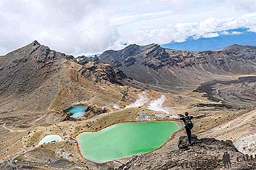
Views of the Emerald Lakes
We advise you to take some time in areas with better views, to enjoy these, since during the descent it is difficult not to keep your eyes on your feet to avoid falling.
Stage 5: Emerald Pools - Blue Lake - 20 minutes
Difficulty: Easy
The main path of Tongariro Alpine Crossing continues along the Central Crater and then take a completely flat area to the Blue Lake. This is the lake is Tapu, sacred to the Maori, so it is forbidden to touch it, bathe, eat or drink on its banks.
In case you want to make a stop to eat something, as we did, stay at the top, from where you will have incredible views, but at all times you will show respect for the beliefs of the place.

Blue Lake
Before reaching the climb that takes you to Lake Tapu, do not stop turning. By doing so you can enjoy one of the most impressive views with the Tongariro and the Red Crater on the horizon. On your right, once you are turned, you will see the impressive lava tongue caused by the last eruption.

Stage 5 of Trekking to Tongariro
Stage 6: Blue Lake to Ketetahi hut - 1:15 hours
Difficulty: Easy (Very tired)
After passing a short and not very steep climb you will reach the North Crater, from where you will have stunning views of Mount Pihanga, Lake Rotoaira and Lake Taupo. At this stage, 95% of the road is downhill and runs through a protected area, so it is important not to leave the marked path or enabled walkways.

Stage 6 of Tongariro Trekking
This stage takes you to the Ketetehai Refuge, where there is a bathroom service. In our case we consider that the difficulty is easy, since it does not involve any risk, the problem is that with the accumulated fatigue and so much time of descent, the knees and legs are loaded so much that at times it seems that you will not be able to continue.
Stage 7: Ketetahi hut to the Ketetahi parking lot - 1:30
Difficulty: Easy (Very tired)
Like the previous stage, this also does not present difficulty, the main problem is that the path continues to be down and at this point it is already a real Break legs. At mid-stage you will cross through the Ketetahi Springs area, which, being private, you must not cross, and then as you go, travel the last kilometers through an incredible forest, which ends in the Ketetahi parking lot.

Seventh Trekking Tongariro Stage

Forest in the Seventh Stage of Tongariro Trekking
Stage 8: Ketetahi Parking - Mountain Shuttle Parking - 15 minutes
Difficulty: Easy (Very tired)
This last stage should only be done if, as in our case, you have hired transport with Mountain Shuttle and have left your vehicle in the guarded parking lot that is one kilometer from the end point of the Tongariro Trekking.
The stage runs through the completely flat road and the only difficulty is the accumulated fatigue of the last hours going down, which make the legs do not respond.

Mountain Shuttle Parking
Tips for doing the Tongariro Alpine Crossing
After the previous explanations about the Tongariro Alpine Crossing and the trekking stages, we want to leave you some tips to do this trek that we believe, they can serve you to organize yourself better and enjoy what they say, it is the most beautiful day trekking in the world.
- The first thing we believe you should do before facing the Tongariro Trekking, is to check the weather and, if possible, monitor it a few days before through an application such as Metservice, which is what the accommodation and shuttle services use. In addition to this, it is advisable if you have any questions, go to the Visitor Center or call by phone so that they give you the last weather report.
Do not forget that although it seems incredible, the weather in New Zealand changes a lot in a matter of hours, but in Tongariro, this happens in a matter of minutes. That you have started trekking with an incredible sun, does not mean that a storm falls midway that makes this trekking the worst of your dreams. That is why it is worth being cautious and taking into account the weather forecast. - Given the above, it is important to wear some coat, long pants, long-sleeved shirt, raincoat, hat, gloves and scarf. Although there are times of the day when it is sunny, you will not use them, it is likely that you need them first and last.
- In addition to clothing, it is important to wear shoes suitable for this type of trekking. We saw people with sandals and sneakers. It is perfectly feasible to do it with this shoe, but we assure you that if you have no experience, it will probably be easier for you to suffer a fall or slip.
- Remember that there are no drinks or food services throughout the Tongariro Trekking. Everything you need you should carry in your backpack. We recommend you not carry too much. Several snacks (nuts or energy bars) and a breakfast snack are enough. It is also important to bring water. We carry 2 bottles of a liter and a half and we have one left over. Rate before loading with more or less weight how much you may need.

Views from the Third Stage of the trekking
- Whenever you can, we recommend you start the trekking first thing in the morning, this will give you room to stop to take photos and rest in addition to taking the walk with more tranquility.
- As we mentioned earlier, for us the difficulty of Trekking Tongariro is not something technical, the main one problem It is the fatigue that you face especially in the last two stages, which are downhill continues, for more than 3 hours and literally break your legs.
On a difficult level, the Red Crater stage, being a steep descent and unstable terrain, is the most complicated, but nothing that can not be done with peace of mind. - If you have vertigo, do not worry. In any of the stages you go through areas where it can play a trick on you. The only area would be the Red Crater, where more than the altitude, the descent through the terrain can be problematic.
- As we also commented at the beginning of the post, we recommend that you do not do this trekking the other way as we have done and 99% of people do it. We saw some travelers doing the opposite and the effort in addition to being double, the views they had were totally different, to always find the most impressive views and landscapes on their backs.

Ngauruhoe views
- In all the brochures we have read, they say that the trekking lasts 6 to 8 hours. We have taken about 8:30 hours making many stops and resting whenever we have needed it. Starting early in the morning, at 7:15 a.m., we arrived at the parking lot at 3:45 p.m., so we still had a very wide margin of time until 5-6 in the afternoon, which is the time in which you should already be in the last stage if you delay a lot.
- Another thing is to keep in mind that although in some blogs you read that you can park on the banks of the Ketetahi Parking road (end point of the trekking), this is currently not the case. Now there are signs that tell you that you can only park 4 hours in these areas, so if you are going to do the trekking, it is impossible to park outside the parking lot.
- It is also forbidden to spend the night in any of the parkings.

First Trekking Stage
Tongariro conclusions
After our experience, we can only recommend trekking to Tongariro. What has really caught our attention is the label of great difficulty that we have seen put many travelers.
We understand that if you do it on a windy or rainy day, the experience must be incredibly hard, but if you do it on a day where the weather is stable, we assure you that anyone, who performs a minimum of physical activity, can do it .
He is tired, we are not going to deny it, especially the last part, in which the descent causes the legs to have moments that you do not notice, but we assure you that at the difficulty level, no technique is required.
The only point "critical" it is the descent of the Red Crater, in which due to the instability of the land, it is most likely that you take a slip. Knowing it, it is important to go slowly, taking precautions and even if you think it is necessary, bring canes to help you.

Tongariro trekking
In short: We will not tell you that it is easy. But we will not tell you that it is difficult or impossible. We will only tell you what can be done, faster or slower, whatever your physical state.
And above all we will tell you: do not let anyone tell you that it is impossible. Do not let anyone put fear in your body and condition you. Think that your fears are speaking to you and they only want you not to try.

Tongariro trekking in New Zealand
And so, after eight hours of intense trekking, we arrive at the Ketetahi Parking, from where we travel the last kilometer to the secure parking of Mountain Shuttle, we meet our motorhome with which we return to the Tongariro Holiday Park, our accommodation in Tongariro, where after of a restorative shower and put a washer and dryer, we dined and fell like children, dreaming of one of the most incredible days we have lived so far in New Zealand.
We leave you the map of the Tongariro Alpine Crossing Trekking route in New Zealand, with all the locations, such as the parking lots of Ketetahi, Mangatepopo, Mount Ruapehu, Tongariro, Mount Ngauruhoe ... etc
 Day 12: Tongariro - Places to see on the Forgotten World Highway: Taumurunui - Moki Tunnel, Whangamomona, Pohokura Saddle, Strathmore Saddle, Makahu Tunnel - Taranak